
Who's A Little Town?
What Do You Think You're Looking At? #209

Readers: This week marks the completion of the fourth year of The Deleted Scenes—that’s four full years (every day except Sunday) of thoughtful, illustrated, locally rooted pieces on urbanism, culture, commercial history, and more. I’m offering a 20 percent discount for new subscribers, good until the end of Sunday. If you’ve been on the fence about upgrading, this is a great time. Your support—reading, sharing, and yes, subscribing—keeps this thing going. Thank you! To year five!
I love the “this building doesn’t belong on this strip, what’s its history and what else used to be here?” genre. And so today I present you:
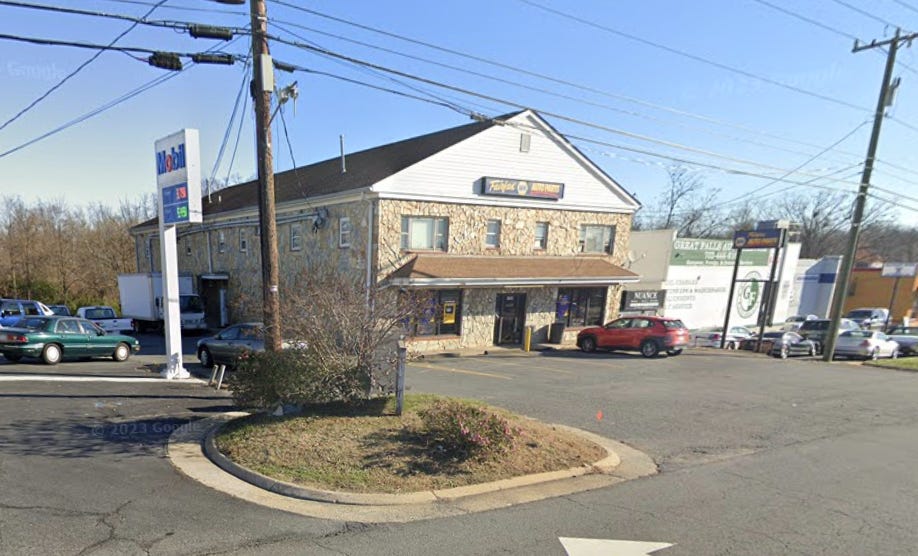
Now this doesn’t look like much. The building itself isn’t particularly interesting. There’s no story here until you look at the surroundings. What’s interesting is the building’s placement, which is incongruous. This is Route 7 in Sterling, Virginia, and the corridor looks like this:
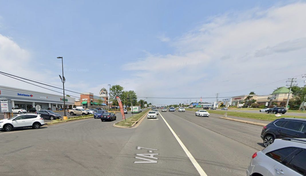
Strip malls, parking lots, traffic lights, turning lanes. Your typical suburban commercial strip. There isn’t very much old stuff along here. If you were just passing through, you’d probably guess it was pretty much undeveloped before maybe the 1980s. Which, for the most part, a lot of Loudoun County was.
But because of that building—two stories, connected to a small building on one side, apparently mixed-use (top-level apartments) or at least a history of mixed uses—you know that this immediate area was in some way developed before that. You know that with no other historical information, simply because there’s virtually no chance of a structure like that getting built in the 1980s.
A search on Loudoun County’s online property data system confirms that: it was built in 1950. Sometimes round numbers like that are errors, but 1950 is correct. People remember it, and aerial imagery shows it present in the late 1950s but not the late 1930s.
Even that seems a bit late to me, but it kind of demonstrates that “urban” buildings were also very much country buildings. If anything, old-fashioned “urban” buildings probably died out in cities and postwar suburbs before they stopped getting built in further-out places where codes were lighter or nonexistent, and where people kept doing things the way they’d always done them.
The questions this building presents are: 1) what else in this older style used to be here? And 2), putting it differently, was this just a little country crossroads, or is this the sole surviving remnant of an actual town that once stood here?
The first search for something came up with “The Lost Town of Dranesville.” And the road that intersects with Route 7 here is Dranesville Road! But wait: the intersection where Dranesville was built is about a mile away. (About the only Dranesville artifact still around is the Dranesville Tavern, which was moved at one point but still stands near the erstwhile little town.) Dranesville declined a long time ago:
The creation of the railroad from Alexandria to Leesburg in the 1850s, followed by the invention of the automobile several decades later, slowly faded Dranesville’s importance. The widening of Leesburg Pike in the late 1960s led to the demolition of many of the older buildings in the town.
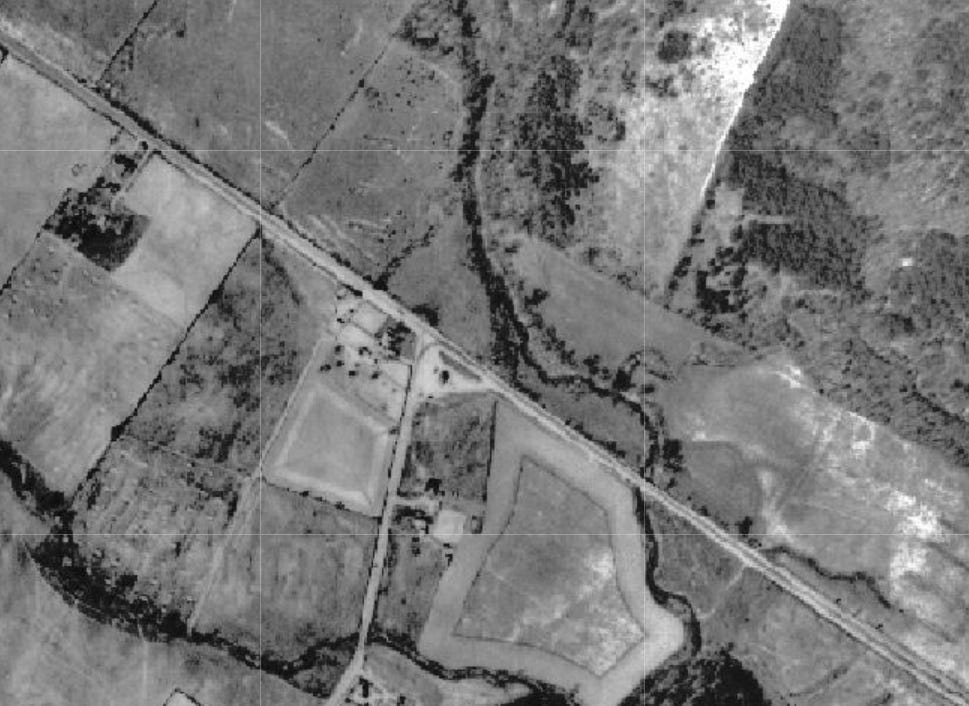
So I’m not looking at the lost town of Dranesville at the intersection of Route 7 and Dranesville Road. I was not able to find from a Google search what the community I was looking at was even called, let alone what happened to it. However, Loudoun County’s aerial imagery did determine for me that I was not really looking at an old town. The vertical road here is Dranesville, and the diagonal road is Route 7. And there’s nothing here but farms. This is 1937:
The next set of imagery, from 1957, frustratingly cuts off at the county line. But right where the imagery ends, along Route 7, you can see a little strip of buildings:
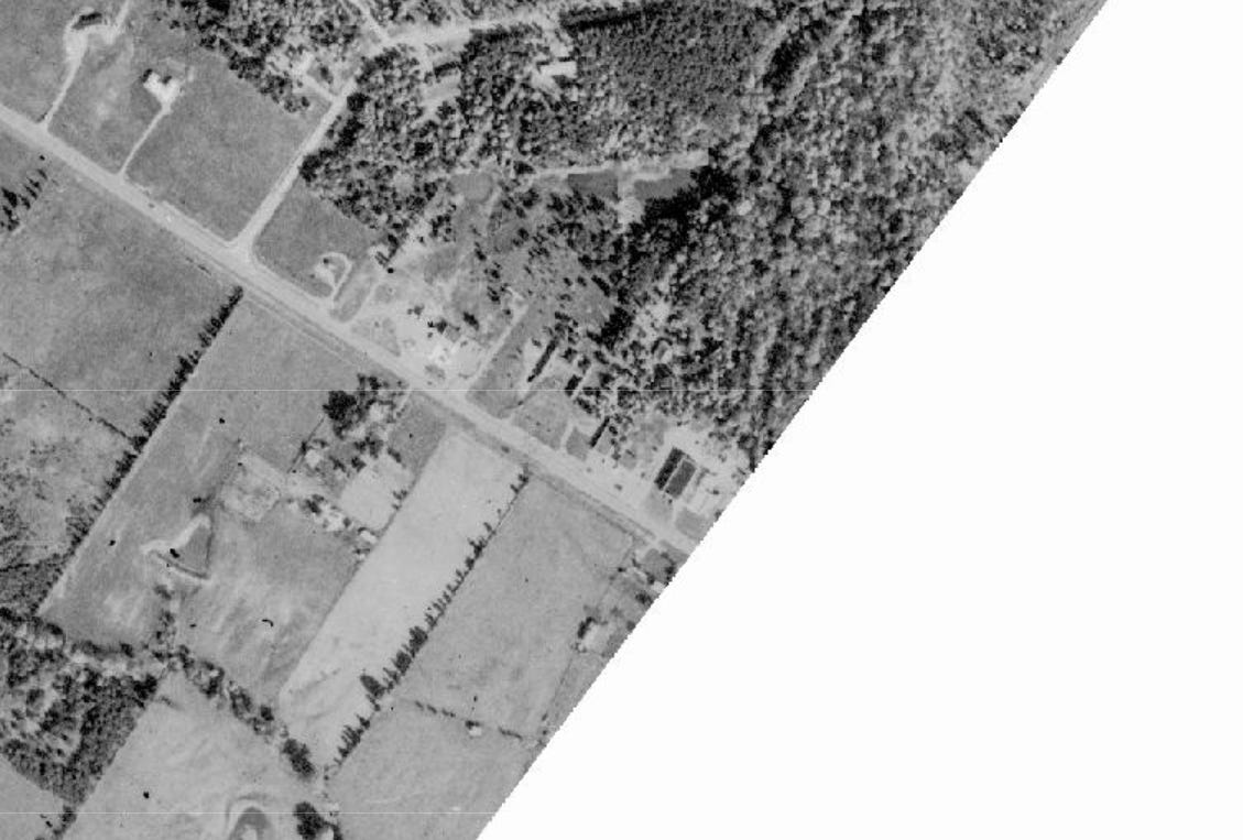
I believe the two-story building I’m focusing on here is the only one still standing. (There’s also a motel a tad to the left, also gone. The next imagery is 2002, which basically is the same as now.)
A Facebook group, Northern Virginia History, helped me a lot in pinning down what exactly this little crossroads was.
The building did, in fact, have apartments on top, and at a later date than you might expect. One commenter says: “I know there are apartments on top. Or used to be anyway. I grew up not far from it and had a friend in elementary school that lived in one of the apartments. I did a sleep over there one time. This was back in the early 90s.” One guy was a mailman whose route included those apartments; another recalls paintballing, target shooting, and maybe some other things in the undeveloped woods behind the building, back then. According to other comments, the apartments are still occupied and in use.
Back in the ’50s and ’60s, the auto parts space was a grocery store. “It was a grocery store in the beginning, had a big old wooden freezer in the very back.” “They had a meat deli counter in the back of the store in the 70s. I used to get cold cut sandwiches there.” It apparently even had a butcher counter with meat cut to order. It’s amazing that that existed out here in 1960, but today lots of big supermarkets don’t even have a real butcher.
There was a barber somewhere in the building (or maybe in a since-demolished different building—folks remember that differently). Another nearby building was home to a sporting goods shop from the 1960s to the 1980s, and—one of the owner’s obituaries online mentions it. Somewhere around here was also a sports card shop. You can even get a sense of inflation back in the day: Walt’s haircuts used to be fifty cents—later on seventy-five. Apparently the McDonald’s on the opposite corner used to be a two-story McDonald’s, too.
I don’t know exactly when the grocery store closed, but it sounds like awhile ago:
I worked at the auto parts store for 31 years and lived in the apartments for 13 years. It used to be owned by Arlis Bowman until my bosses bought it from him. When we bought it we had to knock a hole in the wall to get the deli freezer out and they bought the little building in between and rented it out. That was the barber shop. Lot of fun there. My old bosses still own it. NAPA just bought the business.
Wait, I do know when it closed:
In the late 70s, there was still an enclave of stone-front buildings in that area. A motel (hourly, daily, or weekly), a small building housing the Sport Spot, Bowman’s Store, the little building attached to it, and another taller building on the east end that housed Pastrami Scotts and the Truck Stop. Fairfax Auto Parts bought and remodeled the grocery store in 1986. I worked for the contractor that did the work, Aaron Enterprises, for the Herbert family, owners of Fairfax Auto. (They lived in Oakton)
The inside was a MESS! Full of stuff, including the wooden, walk-in freezer mentioned by another poster. We had to cut it up with saws to get it out. The full basement was indeed Full, with junk from the 40s & 50s, including two old cars, and lots of black snakes! The outside stairs led upstairs to about 6 rooms/ crash pads, occupied by some questionable residents.
That cluster of buildings was one of the few commercial developments between Kerlins Corner (Tysons) and Leesburg on Rt7 in the 60-70s.
Pastrami Scott’s? Here, and here, are two Washington Post pieces about it from the 1980s! And Arlis Bowman’s obituary is also online.
Maybe at some points some of the residents were “questionable,” but this kind of cheap housing is also a resource for people starting out:
My mom and dad lived in those apartments as newlyweds in the later 60s. And the Bowmans were close family friends and neighbors of my grandparents, who had a store over on Church Road that my granddaddy built. That building is still there.
And at least one of the auto parts store employees lived upstairs! Out in a little country outpost. Someone says the apartments were added a year or two later after the initial grocery store/country store was built. Expanding a commercial building like that with a second use is another thing we rarely do anymore. Here is a listing for one of those apartments.
How about that tiny storefront sandwiched between the two structures?
Funny story. I worked at Trek Auto around 2000 (before it became Advanced Auto) and this used to be Fairfax Auto Parts and on occasion we would have to refer people to them for misc parts we didn't carry and they would ask “where is it exactly” and we would say “about 3 miles down 7 on the left right next to Wet Grass, you can’t miss it”. Wet Grass was a little sprinkler store about 5' wide right next door and you would have to squint from the road to see it. I wonder how many people got there and were like “a**holes”. Ahhh. Simpler times..
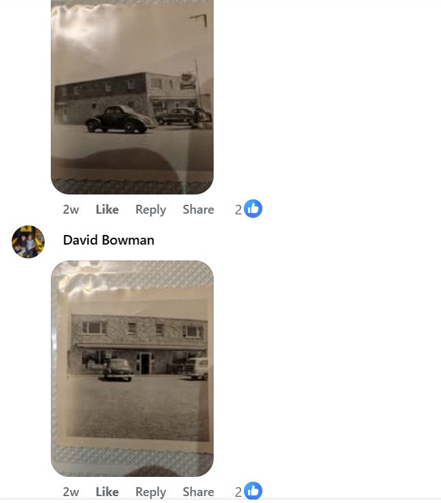
And here, from someone related to the building owners, are photos of the structure early in its life (the roof was raised for flooding issues, apparently):
On the “was this a town?” question, here’s an interesting couple of comments:
Well, growing up in Falls Church and driving 7 frequently for many years, I will only say I never felt like it was a ‘town’….Probably the first time I drove it was around ’70, and made hundreds of trips to Leesburg, Waterford, Shepherdstown and elsewhere out that way. Looks to me like it was more of a town ‘WAAAAY’ back in the day and then got subsumed into Sterling Park.
And:
It’s kind of like Chantilly, which was just a plantation, then a post office with a collection of houses and a church at the intersection of Rts. 28 and 50. They weren’t towns in the sense that Clifton was a town (and still is) with its own government but were recognized as distinct places. Centreville is seen as a town, but I don't think it ever had its own government either.
(This is Clifton, by the way—I wrote about it early on in this newsletter!)
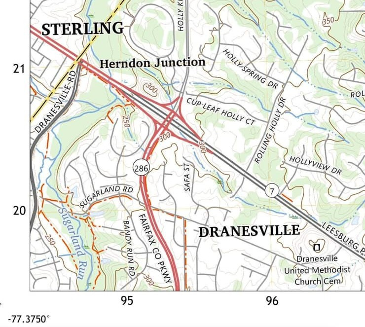
The area did, however, have a name: Herndon Junction. It was recognized as a little commercial district, and, as the building in question here shows, it did technically have residents, not just businesses. USGS maps still identify it as Herndon Junction, even though that name no longer means much of anything nowadays:
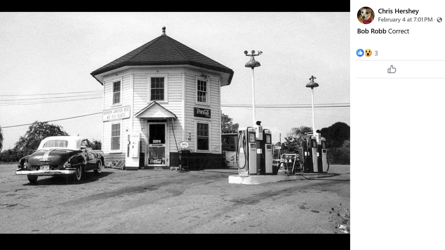
Someone dug up a photo of the Herndon Junction Esso station, which is probably where today’s Mobil station sits:
I think you could probably call this an embryonic town that never grew. What’s somewhat unique about it is that it was built so late into our shift away from traditional urbanism.
If we had not totally shifted away from the old ways of building and organizing places, I wonder if a little crossroads like this might have grown into an actual recognizable town? And then, having grown more, might have remained intact up to the present day?
We often use “old” or “old-fashioned” when we really mean “not done anymore for reasons having nothing to do with age or time.”
Not directly related to any of this, even, is this comment, about one of the people who worked in one of the businesses in Herndon Junction long ago:
I believe he was the son of a slave like John Jackson. John was an incredible musician and he and his brother were Gravediggers. He reburied Richard Bland Lee at Sully. I had lots of interesting conversations with him. He buried my mother in Great Falls.
The things you uncover when you ask about an old building!
Related Reading:
Thank you for reading! Please consider upgrading to a paid subscription to help support this newsletter, discounted just this week! You’ll get a weekly subscribers-only piece, plus full access to the archive: over 1,200 pieces and growing. And you’ll help ensure more like this!
It was Trak Auto, not Trek Auto.
Historic Aerials has a complete set of aerials. Here's the location in 1957 https://historicaerials.com/location/39.0146989896294/-77.37099051475526/1957/16